THE WORLD’S CRAZIEST BORDER
[Note: From the world’s craziest border, tomorrow I embark for the world’s craziest country, in which there is no communication to the outside world. You may not hear from me for the next 16 days. TTP will be in good hands, however, with Miko and Jack Kelly.]
Tin Bigha Corridor, Dahagram-Angarpota Enclave, Bangladesh. For some time now, I’ve been preparing a research study for the Asia Subcommittee in Congress on India vs. her neighbors. Here is one key place to do so. What follows will be incorporated into the research study.
There are a lot of maps and pictures I took over the past few days. I think you’ll find it all mind-blowingly informative.
India borders seven countries – Pakistan, China, Nepal, Bhutan, Burma, Bangladesh, and Sri Lanka. This is a government map of India composed of 28 states and seven union territories.

This is a map of Bangladesh. In the top left corner, there is a town called Pachagarth. Focus on the little finger of land sticking above the last “h” in Pachagarth.
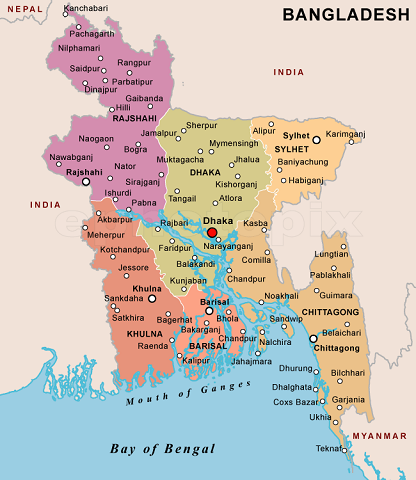
The main town in that finger of land is called Patgram. Get ready for this. This is a detailed map of the Patgram section of the India-Bangladesh border:
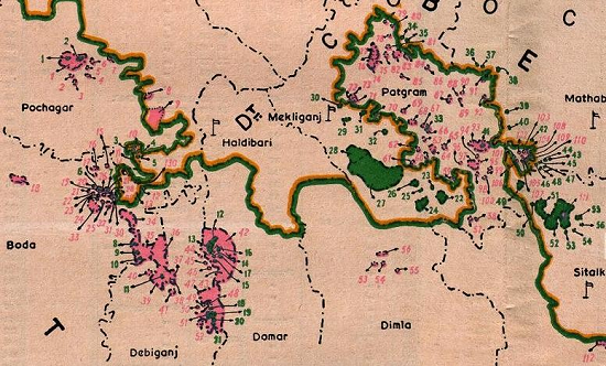
The India border is the brown line, Bangladesh’s the green. All the pink numbers and areas denote Indian enclaves, or areas of sovereign Indian territory, inside Bangladesh. All the green numbers and areas denote Bangladesh enclaves inside India. The largest green blob, numbered 27/28, is Dahagram-Angarpota. Look closely and you’ll see that the brown India border line separates it from “mainland” Bangladesh.
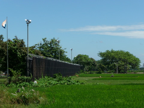
That separation is a gap of less than 200 yards. Yet the Indian government maintains that border, walling off the 7 square miles of Dahagram-Angarpota with high electrified barbed wire fences, and watchtowers with armed Indian soldiers. Finally, it allowed a heavily fenced corridor about 150 feet wide, manned with Indian army soldiers, to connect the enclave – home to 20,000 Bangladeshis – to the outside world: the Tin Bigha Corridor.
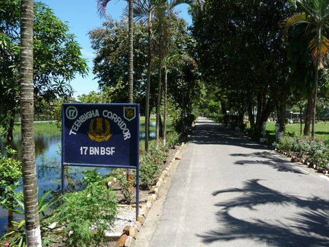
For years, the people living in Dahagram-Angarpota had no services whatever. The Indians would not allow Bangladesh to provide electricity, hospitals, or schools. Slowly and begrudgingly, they have been allowed recently. A year ago, they finally got electricity.
Look at these kids at the Dahagram primary school. Why would anyone want to deny them a decent life out of spite for a ludicrously insane border? Why would any government insist they own the 200 yards isolating them from the world, and surround them with electric fences and watchtowers?

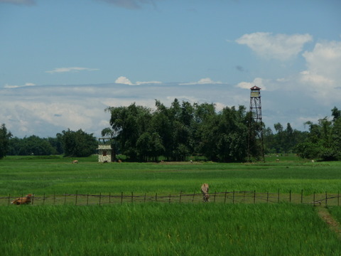
The world’s craziest border is that of northwest Bangladesh with India. There are 92 Bangladesh enclaves inside India – and there are 111 Indian enclaves inside Bangladesh. Here’s the full border map, drawn when Bangladesh was still East Pakistan.
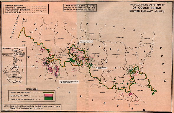
It’s the best I could find. The only way I know to see the total ridiculousness of this border’s complexity is with Google Earth. Enter “Rangpur Division, Bangladesh” in the Search box, then zoom in. You’ll not only see a crazy quilt of enclaves, but enclaves within enclaves – Bangladeshi enclaves inside Indian enclaves inside Bangladesh, and Indian enclaves inside Bangladeshi enclaves inside India.
There’s even an Indian enclave inside a Bangladeshi enclave inside an Indian enclave inside Bangladesh – the world’s only “counter-counter enclave.”
It’s actually a small jute field of a couple of acres with no one living on it called Dahala-Khagrabari. I couldn’t get to it as this required crossing a river with no ferry. But I did reach the Bangladeshi enclave that surrounds it, Upanchowki Bhajni, which is inside the largest Indian enclave inside Bangladesh, Balapara Khagrabari or BK. BK is the largest pink blob in the Patgram area map above, north of the Bangladesh town of Debiganj.
Bangladesh does not surround Indian enclaves with fences, watchtowers, and armed guards. There are no physical borders at all, other than small stone markers mostly hidden in underbrush, or ancient earthworks. On the left side of these earthworks is Bangladesh:
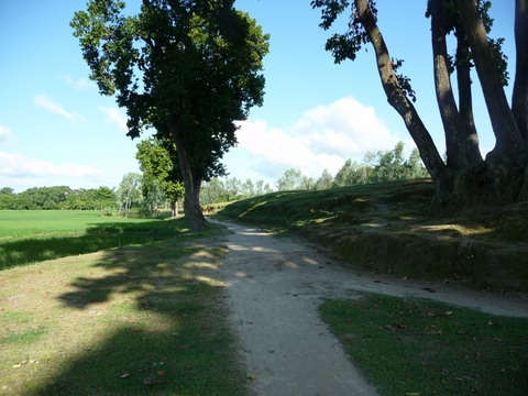
On the right side is India inside Bangladesh:
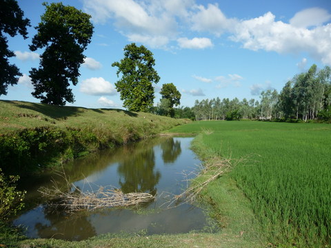
The border is political, not physical. Almost no Indians still live in the Indian enclaves, who left long ago. With 150 million Bangladeshis living in a country the size of Iowa, locals moved in and started living and farming in them. These kids and their parents have lived in the BK enclave all their lives:
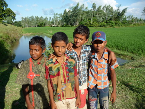
And thus they are stateless. They have no citizenship, for the Indian government refuses to let the Bangladeshi government recognize them, refuses to allow schools or electricity or medical services be provided in its “Indian” territory. It’s crazily inhumane – but par for the Indian course. Here is a story (March, 2012) of folks living in Indian enclaves demanding Bangladeshi citizenship.
All of these stupid enclaves are an old legacy of disputes between various Hindu rajahs and Moslem sultans before India was stitched together by the Brits in the 19th century – and which the Brits stupidly allowed to continue when it stupidly allowed its greatest colonial achievement to split up into Hindu India with Moslem West and East Pakistan on either side: see The Lunacy of a British Legacy from July 2006, with pre- and post-partition maps.
Yet the Indo-Bangla enclave border is but the craziest part of the world’s craziest border. Notice on the India map above that Bangladesh is surrounded by India except for Burma in the extreme southeast. Let’s focus on that:

On the west side and the northwest enclave region, there’s the Indian state of West Bengal. Then wrapping around it from the northeast and east to Burma (Myanmar) are Indian states known collectively as “the Seven Sisters” – Megahlaya, Assam, Arunachal Pradesh, Nagaland, Tripura, Manipur, and Mizoram.
Last week I was in the Bangladesh state of Chittagong (see Bangladesh map above) near the Indo-Burma border. This is a large mountainous region inhabited by hill tribes of non-Bengali Tibetan-Burmese ethnicity, which the crazy Brits sliced in half, giving one part to Moslem-Bengali East Pakistan (Bangladesh), and the other to Hindu India.
Yet these ancient hill tribes, such as the Chakma, Bowm, Marma and Murung, are neither Moslem nor Hindu. They are either traditional animist, Buddhist, or Christian. They inhabit the entire Bangladesh-Indo-Burmese border area. And once again, the Indian Army has armed soldiers there.
Unable to build a electrified fence with concertina wire like in the enclave area, the Indians have declared a no-man’s land on the border – and should a tribesman enter it trying to find one of his wandering cows, Indian soldiers will shoot him dead. No matter how many tribespeople are killed this way – dozens every year – the Bangladesh government only raises the quietest of complaints as it is so intimidated by their giant “Big Brother” Indian neighbor.
The Burmese, by the way, don’t do this – the tribespeople are pretty much free to cross back and forth and actually don’t really know, except for a few checkpoints, where the Bangla-Burma border is.
This is a stunningly beautiful area…
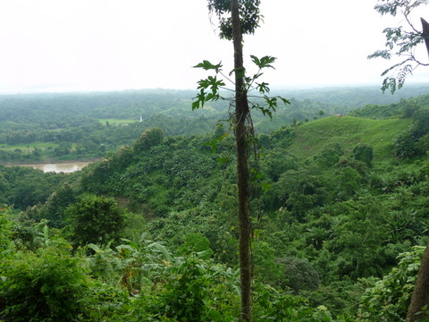
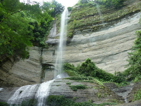
Whose people live simple lives…
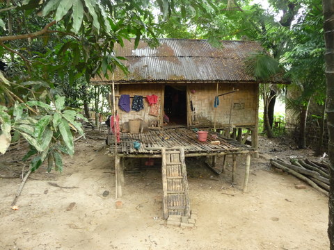
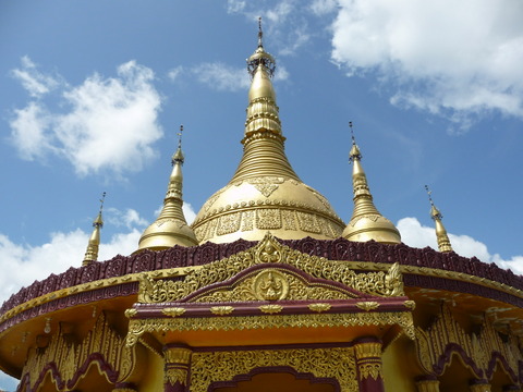
They worship at Buddhist temples…
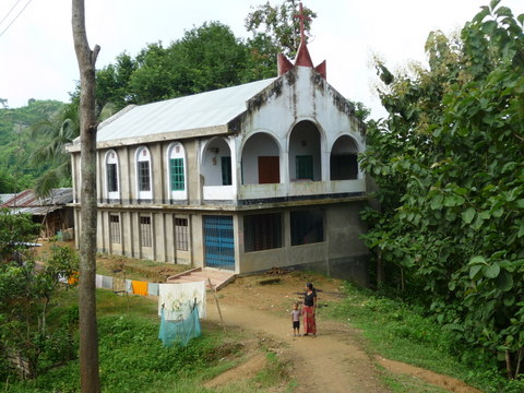
And Christian churches…
They are charmingly friendly and peaceful people. Here is a Buddhist Chakma lady…

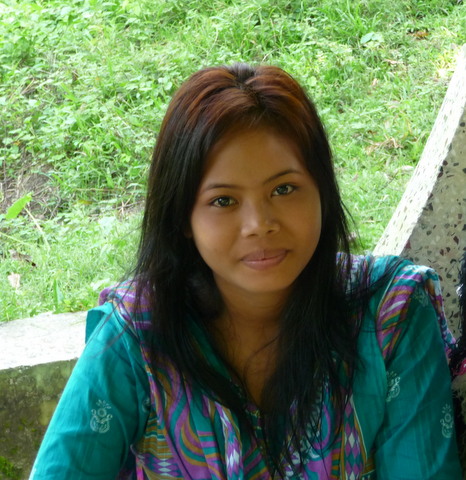
And a young Christian Bowm woman…
Then there’s always the kids. Here are some goofing around in a Christian Bowm village…

So the Chittagong Hills form another part of the world’s craziest border – which is the entire border of India with all its neighbors. There is not a single neighbor state that India has as an ally or friend, or is not in some kind of dispute with.
See those two striped areas in the top left part of the India map above marked “Jammu & Kashmir”? The Pakistani part belongs completely to Pakistan; India has no sovereignty or control over it whatever, however much India continues to stridently insist it does. Same with the Chinese area, known as the Aksai Chin.
Meanwhile, China claims all of Arunachal Pradesh (AP, one of those Seven Sisters). All India has to do to settle the dispute is recognize Chinese sovereignty over the Aksai Chin, and Beijing will do the same for AP – but Delhi perversely refuses.
Thus the Indo-Sino antagonism continues, and is extended into Nepal, run now by a pro-Chinese Maoist Communist government. India continues to antagonize Bhutan, a devoutly Buddhist land under attack by hordes of Nepali Hindu refugees. India supports the Hindu illegal aliens and demands they be made Bhutanese citizens. (See Saving Shangri-La from December 2004.)
India barely gets along with Burma, which is why the latter is increasingly aligned with China. India allows only two crossings – the Pangsau Pass (the Hell Pass of Vinegar Joe Stilwell’s Burma Road in WWII) way up in Assam, and at Moreh in Manipur, both of which are unpaved 4WD tracks – along its entire 1,100 mile border with Burma.
And in Sri Lanka, India has indelibly alienated the Buddhist Sinhalese (75% of the country) by supporting the Hindu Tamils in their secessionist terrorism. It was China who came to their rescue, arming and training the Sri Lankan Army to defeat the Tamil Tigers in 2009.
Bangladesh’s current government under Prime Minister Hasima desperately wants good relations with India – but at every turn meets with that insufferable Brahmin arrogance that characterizes Indians in authority. Anyone who has dealt with them understands. The intractability of suffocating Indian bureaucracy drenched in that arrogance cannot be overcome.
As the London Economist noted recently, this is bringing about the end of all the optimism regarding the Indian economy. India is in trouble – and friendless to boot.
As her economy and promise of prosperity for her impoverished hundreds of millions heads down the drain, India finds herself alienated from her every neighbor, while crippled by the world’s craziest border her successive governments have made no effort to render sane.
You’d think, with one glance at the map, that the very first effort would be to befriend Bangladesh. For there is an even crazier place on that map than the hundreds of enclaves within enclaves. How is that possible? Look at the map of India above once more. Note that the northwestern-most tip of Bangladesh almost touches the southeastern corner of Nepal.
All that connects mainland India from northern West Bengal and the Seven Sisters is a tiny 15-mile wide sliver of Indian territory called the Siliguri Gap (named after the main Indian town in it). Its story is told in Mumbai and the Siliguri Gap, from December 2008 shortly after the Pakistan-sponsored Moslem terrorist attacks in Bombay.
My article about the Siliguri Gap chokepoint contains a short history of Islam in India. It quotes historian Will Durant’s observation that:
“The Mohammedan Conquest of India is probably the bloodiest story in history. It is a discouraging tale, for its evident moral is that civilization is a precarious thing, whose delicate complex of order and liberty, culture and peace may at any time be overthrown by barbarians invading from without or multiplying within.”
Here is the update on this from Bangladesh. You’d think that India would be doing whatever it could to prevent Bangladesh from becoming a Radical Moslem terrorist state. But no.
Prime Minister Hasima is doing a good job. There is enormous food production with no hunger and starvation. Moslem Banglas (Bengalis) are adherents of Sufi Islam. See Islam’s Anti-Osama from January 2004 for why Sufism is the peaceful form of Islam.
Wahhabi/Salafi Islam is the antithesis of Sufi Islam, which is why the Wahhabis hate Sufis more than us infidels. And every day they grow stronger now in Bangladesh. Opposition leader Khaleda Zia is on the Saudi payroll, her Bangladesh Nationalist Party financed by the Saudis and the Pakistan ISI (Inter-Service Intelligence).
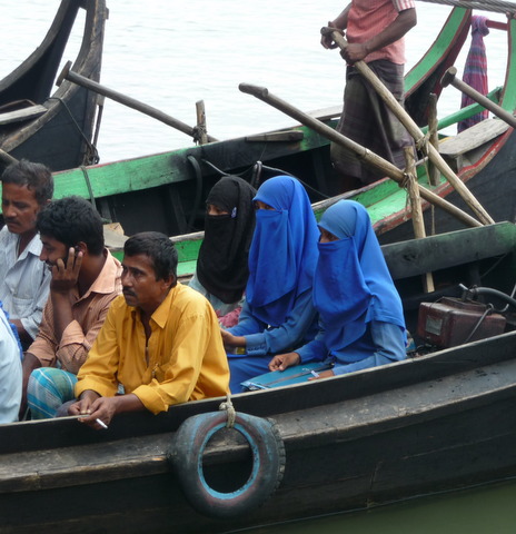
Pakistan Imams trained in Wahhabi madressahs are all over Bangladesh now, preaching their religion of hate in mosque after mosque. The great majority of Bangla women wear no veil, much less a burqa. But women in burqas are becoming an increasingly common sight:
Bangla reporters and journalists are on the Wahhabi payroll as well. Hasima is under constant media attack. BNP protest rallies demanding her resignation happen every day. Driving through one that’s taken over a town’s streets, as I did a couple of days ago, is no fun.
What mischief could a Wahhabi Bangladesh create at the Siliguri Gap? That’s only one of a myriad of questions as the world’s craziest border gets crazier. Zero, of course, is oblivious and insouciant to all of this. The world as a whole will get far more dangerously crazy should he win in November.
It’s not just the fate of America at stake on November 6th. So is that of a lot of the rest of the planet. A sane foreign policy of President Romney and Secretary of State Bolton will come just in time – if American voters possess the sanity to achieve it.

